04-28-2021
Comment to the journal-contribution:
Capezzuoli, E. et al.: Reconsidering the Variscan
Basement of Southern Tuscany (Inner Northern Apennines),
Geosci., 2021, 11(2): 84, http://doi.org/10.3390/geosciences11020084
This contribution concerns the geology of
the Monticiano-Roccastrada Range, a still underexplored
Tertiary metamorphic core complex (MCC), compared to the
Pisan Mounts and Apuan Alps. Both the latter are
interpreted as their geological continuations - similar
in structure and lithology - to the NNW (Mid Tuscan
Ridge).
One general point of interest and importance must be
declared in advance: a scientific model can not be better
than the quality of the results/findings on which it
stands on or from which it is derived of. This means in
the case here: basic requirement for a reliable,
high-quality model of the stratigraphic and tectonic
evolution of the Monticiano-Roccastrada MCC is thorough
geological survey, i. e. mapping work, which must be
accomplished as carefully and accurately as possible.
Because the complexity-grade of the geomorphologic
pattern of the area is rather high, difficult geological
situations are expectable and the information found needs
sensitive and careful interpretation. According to the
physical accessibility of the mountainous terrain - few
roads and paths; lots of macchia - , the realisation of
this compellingly high demand means strenuous work.
According to own experience, time consuming and
exhausting step by step mapping work is a basic
requirement; and the detectability of geological
boundaries is hindered and is interpretation complicated,
because nearly all of them are covered beneath late
Quaternary detritus.
The reasons for discussing this paper: not comparable
mapping results from identic regions at Rio Risanguigno
(Figs. 1, 2) near Monticiano and at Ferriera di Ruota
(Figs. 3, 4) in the western part of the Farma Valley of
different revisers (responsible persons); as well as
thereof derived differring geological interpretations
concerning tectonics, lithostratigraphy, palaeontology
and palaeogeography.
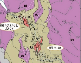
Fig.
1
(Excerpt from Capezzuoli et al. (2021) in Geosci.
11(2), 84, Fig. 5a)
|
Fig.
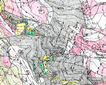
2
(Excerpt from Engelbrecht: 2005)
|
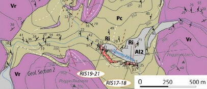
Fig. 3
(Excerpt from Capezzuoli et al. (2021) in Geosci.
11(2), 84, Fig. 5b)
|
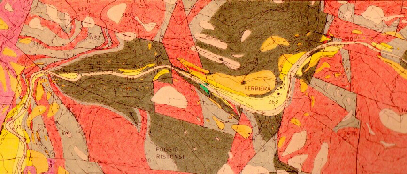
Fig. 4
(Excerpt from Engelbrecht 1997a)
|
Figure captions
Figs.
1, 3: Abbreviations: Ri: Risanguigno Fm.
(Early Carboniferous: Middle Mississippian); Pc:
Poggio al Carpino Fm. (Middle-Late Permian:
Guadalupian-Lopingian); Vr: Verrucano Group
(Early-Middle Triassic: Late Olenekian - Late
Ladinian); Al2: terraced Alluvium
(Pleistocene-Holocene). RIS1-7 etc.: Sample
numbers. Short line with triangle: dip of
sedimentary stratification; short line with
dashes: schistosities S1, S2. Thin straight line:
profile. Symbols: white and red, continuous and
dashed lines: F1 and F2 axial planes of syn- and
antiforms.
|
Fig. 2, 4:
colours: green: Risanguigno Fm.: Early Devonian -
Early Carboniferous (Late Emsian -
Mississippian); black: Poggio al Carpino Fm.:
Carboniferous; grey: Civitella marittima Fm.:
Permian. Verrucano Group: red: Monte Quoio Fm.
(Anisian); violet: anageniti minute (Ladinian).
pink: Tertiary peneplain, yellow: Quaternary
terrace. Short lines with dashes: dip of
sedimentary stratification. Implied tectonic
structures: Dashed lines: normal fault, wrench
fault, shear fracture; lines with triangles:
overthrust; lines with crosses, rhombs: syn-,
antiform. |
The structural division of the Monticiano Roccastrada and
Monte Leoni MCCs into subzones proposed by Capezzuoli et
al. (2021: 05: Fig. 4) is not accepted, because the drawn
in line does not separate coeval formations deposited in
different palaeogeographical terrains. See also http://www.umweltgeol-he.de/discussion2.htm
and Fig. 2 in Zeitschrift
der Deutschen Geologischen Gesellschaft 148/3-4: 523-546.
The Risanguigno Fm. is indicated in Fig. 4 of
Capezzuoli et al. (2021) exclusively in the western part
of the Monticiano Roccastrada MCC. However, this
Formation is also present in its eastern area according
to Pasini & Vai (1997) and Engelbrecht (1997).
Page 1: The statements "...the scarcity of
fossils remains ....." and "... in
absence of fossil records..." contradict each
other.
Page 2: It is stated in the chapter about "Geological
outline of the Palaeozoic Units of Tuscany" of
Capezzuoli et al. (2021: 04) that the Late Tertiary
exhumation of the formations has occurred via extensional
detachments, which resulted in "megaboudins"
and "lateral segmentation of previously stacked
tectonic units".
Tectonic segmentation via normal faults, wrench faults,
shear fractures - inferred also from the presence of
joints and slickensides - has been observed; see Figs. 2,
4: Both areas resemble megabreccias, because they are
composed of tectonic blocks, made up of folded and/or
thrusted sequences consisting of Risanguigno Fm., Poggio
al Carpino Fm., Civitella marittima Fm. and Monte Quoio
Fm.. Inferred b-axes persist on max. 350m. Isoclinic
folds were rarely observed; when present, they even occur
in competent lithologies like thick layered
quartzconglomerates; however, refolding of isoclinic
folds in competent lithologies was not observed.
Large-scale tectonic overturning could not be
ascertained. Some of the strike directions of the faults
bounding the segments correlate with main directions of
the geographic morphology and the drainage system.
This tectonic style contrasts with that one outlined in
Figs. 1, 3: it is devoid of fracture bounded tectonic
blocks and consists essentially of F1 folds - inferred to
persist up to 500m in strike direction - , occasionally
refolded by F2 events; see also profiles in Capezzuoli et
al. (2021: Fig. 5). Extensive tectonic overturning -
> 500m thickness - delineated in the profiles is
not sustained by data (e. g. sedimentary polarity of
strata) in the geological maps. The presented tectonic
structure in Figs. 1 and 3 is in logical conflict with
the statements in the "Geological outline..."
cited above and hardly comparable with the contents of
Figs. 2 and 4. It is doubted whether Figs. 1, 3 prove the
assertion that "A detailed field survey was
carried out in key areas where the Risanguigno Fm is
exposed." (page 9). Fig. 5b in Capezzuoli et
al. (2021) does not found on the map in Engelbrecht
(2008: Fig. 2), as stated in the figure caption. No
bearings of fractures/faults are present in the maps of
Fig. 1, 3, which can be correlated with the main
directions of the geographic morphology and the drainage
system. Moreover: No reasons are given, why exactly the
maps of Figs. 1, 3 are devoid of faults, although
mentioned as common features in the "Geological
outline...". Notabene: Thesis Engelbrecht
(1997a) was sent in 2001 to the head management of the
Dipartimento di Scienze della Terra, Università di
Siena.
Page 4: The elaborate forms of arrows marking
geographic locations in Fig. 3 in Capezzuoli et al.
(2021) are not necessary.
Page 6: "...the base of the Risanguigno Fm.
is never exposed...". The exclusiveness of this
statement is risky, because it takes for granted that the
working group has thoroughly and completely investigated
the whole terrain (ca. 280 km²), that it has never
errored, and because it may occur that new outcrops
manifest the contrary. The possibility of new data from
drillings in future was not taken into consideration. The
text continues: "... although [20] (Engelbrecht
2008: 292) postulated the presence of a basal
stratigraphic unconformity separating the Risanguigno Fm
from the underlying Variscan deformed units."
This statement was given in the chapter
"Interpretation of depositional setting". It is
logic that this postulation aimed not at the actual
situation, but.at the depositional state prior to the
alpine orogenic cycle, as e. g. outlined in Cassinis et
al. (2018: 483, 491). Concerning the actual state,
Engelbrecht (2008: 283) wrote that "...the
stratigraphic base of the Risanguigno Fm. is not
exposed."
Page 7: "...a chert subsequence, up to 4.5 m
thick and intercalated with fine grained clastics, was
also recognized in close outcrops by Pasini & Vai
(1997), and later correlated with the small chert
sequence present also in the Risanguigno type locality
(Engelbrecht 2008). Pasini & Vai (1997: 188) did
not estimate the thickness of the chert subsequence
present in the eastern part of the Farma Valley.
Engelbrecht (2008) did not correlate this chert
subsequence with that one of the type locality, because
this seemed impossible due to intense tectonic
deformation at P 170 in the eastern part. Instead
Engelbrecht (1997b, 2008) attempted to correlate the two
chert- and lydite-key-horizonts pesent at Ferriera di
Ruota and at the type locality via lithological logs.
The text continues in the same paragraph with a debate
about the presence of anhydrite in silicified limestones
of the Risanguigno Fm.; immediately followed by the
statement that post-tectonic Chd blasts were reported in
siliciclastic subsequences. This kind of mixing of
unrelated geological themes (depositional milieu of
Palaeozoic carbonates - Tertiary metamorphic blastesis in
siliciclastics) is confusing to the reader.
Page 7: The authors state that the Risanguigno Fm. has
preliminarily been attributed to the Tournaian-Visean
based on radiolaria found by Pasini & Vai (1997) in
the chert subsequence. But Pasini & Vai (1997: 188)
did not mention radiolarian species; they just refer to
"cherts: lyditic radiolarites" of
probably Dinantian age. They clearly distinguish this
chert subsequence from the Risanguigno Fm., which they
definitely attributed to the Devonian. Puxeddu et al.
(1979: 241) also mention radiolaria, but do not refer to
radiolarian species; they too attribute the Risanguigno
Fm. to the Devonian.
Page 7: The statements "Rocks are strongly
deformed, making the stratigraphic reconstruction
difficult." and "...the complete
stratigraphic reconstruction is prevented by an intense
folding..." on page 9 contradict each other.
Notabene: The Risanguigno Fm. at Ferriera di Ruota is
tectonically less deformed than the sequence at the type
locality, so that Engelbrecht (1997a: 28-33) attempted to
set up a lithological log.
In table 1 on page 8 the spelling of "lidyte"
in the lines of the description of the samples RIS 5, 6
is incorrect.
Page 9: it is stated that "Along the Farma
River ... close to Ferriera ... the 4.5 m thick
chert sequence evidenced by Pasini & Vai (1997)
constitutes the main lithological variation...".
This is confusing, because Pasini & Vai (1997) refer
to the outcrops at P 170 in the eastern part of the Farma
Valley. The thicknesses of both chert-lydite subsequences
were estimated by Engelbrecht (1997a, b) in the western
part at Ferriera di Ruota and at the type locality. The
following statement that "...the chert beds are
positioned at the top of the succession, immediately
below the Poggio al Carpino Fm." is incorrect:
see profile in Engelbrecht 1997b: 536): the amount of
chert layers successively diminishes towards the top of
the formation and siliciclastics begin to prevail
(Engelbrecht 1997a: 28).
Pages 10-11 and 15-16: Despite the fact that the
palynofloral assemblage was "... strongly
degraded..." - because of subduction-related
(HP-LT) metamorphic peak conditions of 350-400°C and 103 MPa - and "characterized
by pseudosculpture induced by deposition of pyrite
crystals", species attributions of many
individuals were given in detail; even type species.
However, systematics, specifica and characteristics of
the microfloral specimens are lacking. Species
attributions of some specimens in Fig. 7 are doubted: The
terms Spelaeotriletes balteatus (Playford) Higgs 1975 and
S. pretiosus (Playford) Neves and Belt 1970 were
considered by Brittain
& Higgs (2007: 113-114) as "Combination
invalid" and the specimens of Fig. 7.9 and 7.12 on
page 11 differ significantly from the referring specimens
in Fig. 3 on page 112 in Brittain & Higgs (2007). The
latter also accounts for the specimen termed Perotrilites
magnus Hughes and Playford 1961, when compared with
Hughes, N. F. & Playford, G. (1961): fig. 5, 6 on
plate 2 in Micropaleontology,
7/1: 27-44: Palynological reconnaissance of the Lower
Carboniferous of Spitzbergen. The same accounts to
Claytonispora distincta Playford and Melo 2012 in Fig.
7.1, when compared with G. Playford, G. & Melo,
J.H.G.: Miospore palynology and biostratigraphy of
Mississippian strata, Amazonas Basin, Brazil (Part One),
American Association of Stratigraphic Palynologists,
Contributions Series No. 47, p. 74-75: plate 6, fig. 17;
plate 7, fig. 1-2, p. 76-77, Dallas, USA.
Page 13-14: "Mica domains are mainly composed
of fine grained white mica and biotite...":
Redundant content.
Page 16: It is stated that the dolostones sampled for
conodonts were barren and that "...the younger
aged rich microflora, suggests that the previously
reported conodonts were reasonably reworked fossils."
Only five samples were investigated in order to test the
reproducibility of the results in Bagnoli & Tongiorgi
(1979); the amount of material processed therefore and
accompanying finds of other microfossils were not
mentioned. No argument was given and no sedimentological
investigation described, which proves the postulated
redeposition of the microfauna described by Bagnoli &
Tongiorgi (1979). Distinctive sediment-textural marks of
redeposition would have even then been recognised by and
evaluated by Bagnoli & Tongiorgi (1979). Reworked
palynofloral assemblages of Devonian age and
non-redeposited - in situ - microfossils of Early
Carboniferous age were not described.
"... the presence of ornamented spores and
tetrads suggest a proximal depositional environment since
the spores were selected according to their hydrodynamic
equivalence": regarding the poorly preserved
state of the specimens caused by synsedimentary
pyritisation and medium grade (HP-LT) metamorphism, it is
doubted whether it is possible to estimate reliably the
proximality of the depositional area of the spores in
relation to the degrees of integrity-defects caused by
aquatic transport.
"... we interpreted the Risanguigno Fm as being
deposited during the Middle Mississippian in a
shallow-marine epicontinental setting, characterized by
starved, anoxic condition in its lower portion and
progressively evolving to carbonate-radiolarite platform."
This palaeogeographic interpretation is not justified,
because sustaining sedimentological and geochemical data,
as given in detail in Randon & Caridroit (2008), are
not present. Siliceous sediments as major components of
epicontinental platform deposits are unknown. The
outcropping thickness of the Risanguigno Fm. was
estimated at min. 40m (Engelbrecht 2008); but this value
is by far not enough to characterise it as epicontinental
platform deposits (see below).
Page 17: The age attributions for subunits 2 and 3 in
Fig. 11 are doubted; see Engelbrecht (2008) and
discussions 1-3.
"... presence of middle Carboniferous (late
Visean - early Namurian...) clasts, bioclasts and
olistoliths embedded within the middle-late Permian Farma
and Carpineta formations (70)": This has never
been stated by Engelbrecht (2000): mentioned formations
were attributed to the Carboniferous and the statement of
olistolithic origin of the San Antonio- and Botro al
Confine Lst. deposits was rejected.
Page 18: "... fairly narrow continental or
epicontinental domains. These depositional features could
have favoured the low energy, anoxic environments."
This statement remains unclear, because no reasons for
elevated influx of nutrients having caused eutrophication
are mentioned.
"... development to carbonate platform (Calcare
di S. Antonio Fm)": The thickness of that
formation is estimated to a few tens of meters (< 35m)
only and cannot be termed as carbonate platform like the
Early Cambrian Gonnesa Limestone, the Middle Permian
Capitan Reef, the Late Triassic Dolomia Principale or the
Early-Middle Cretaceous Urgonian Lst.. Engelbrecht (2008:
297) interpreted the S. Antonio Lst. as small scale
biostromal accumulation, which developed in the outer
shelf area.
"This setting, localised in the Variscan
foreland, evolved to open marine during the
Pennsylvanian-Permian without any involvement in the
Variscan Orogenesis". This statement is
illogic, because the sedimentary piles of depositional
systems developed in forelands are transformed to
structural components like tectonic fragments or wedges
in fold-thrust-belts of each orogen. The development of
basin geometry and dynamics (depth, thickness of pile,
detritus flux, compressional, transpressional or
dilatative regime) is controlled by orogenesis.
"... Tuscan Palaeozoic-Triassic sedimentary
succession (Phyllite-Quartzitic Group ...), classically
considered as "post Variscan" and now
comprising the Middle Mississippian Risanguigno Fm, is no
more to be related to the Variscan Orogenesis."
If this statement would be correct, the depositional area
of the Risanguigno Fm would have established in that
parts of the Gondwana continent not affected by the
Variscan orogenesis; e. g. in the Devonian-Carboniferous
parts of the palaeozoic Amazonas Basin developed in
SW-Gondwana.
The expressions "isolated ... formation",
"scattered fossils", "determnination
of Variscan formations", "mostly
exposed", "close outcrops",
"supplementary outcrop", "never
described before", "bigger crystals",
"symmetric or asymmetric microfolds",
"scenario with fallouts", "reasonably
reworked", "up to lower Permian",
"... older cropping out deposits..."
are not present in the list of termini technici.
According to the explanations and comments above, the
proposal is made to better withdraw that publication to
prevent further confusion and trivialisation in academia.
I am worried about the academic niveau of that paper.
Hubert Engelbrecht
References cited:
- Bagnoli, G. & Tongiorgi, M. (1979): New
fossiliferous Silurina (Mt. Corchia) and Devonian
(Monticiano) layers in the Tuscan Paleozoic.- Mem. Soc.
Geol. It. 20: 299-311, Roma.
- Cassinis, G. et al. (2018): Post-Variscan
Verrucano-like deposits in Italy, and the onset of the
alpine tectono-sedimentary cycle, Earth-Sci. Rev. 185:
476–497, http://doi.10.1016/j.earscirev.2018.06.021
Engelbrecht, H. (1997a): Zur Geologie der Zone von
Monitciano-Roccastrada, Südtoskana, Italien); thesis,
236 pages, Utz Verlag, Munich.
- (1997b): From Upper Palaeozoic extensional basin fill
to late Alpine low grade metamorphic core complex:
preliminary note on the sedimentary and tectonic
development on the Monticiano-Roccastrada-Zone (MRZ;
Southern Tuscany, Italy).- Z.
dt. geol. Ges.; 148/3-4, pp. 523-546,
Stuttgart.
- (2000): Tempestite deposition in the eastern Rheic
Strait: Evidence from the Upper Palaeozoic in Southern
Tuscany.- FACIES
43:103-122; Erlangen.
- (2005): Unpublished geological map unraveling the
geological context between the type localities of the
Poggio al Carpino- and the Risanguigno Formations (Farma-
and Risanguigno Valleys, Monticiano area, Southern
Tuscany, Italy). Archive H. Engelbrecht.
- (2008): Carboniferous continental margin deposits in
Southern Tuscany, Italy: results from geological mapping
of the geotopes Farma Valley and San Antonio Mine area.- Geological
Journal, special issue, vol. 43/2-3:
279-305, Chichester, UK.
- Pasini, M. & Vai, G.-B. (1997): Review and updating
of the Moscovian to Artinskian marine rocks in peninsula
Italy. In: Tethys: Stratigraphic Correlations;
Crasquin-Soleau, S., De Wever, P. (Eds.), Geodiversitas:
Paris, France, 1997; Volume 19/2: 187-191.
- Puxeddu, M.; Raggi, G.; Tongiorgi, M. (1979):
Descrizione di alcuni sondaggi e osservazioni geologiche
nel Paleozoico della zona di Monticiano (Siena). Mem.
Soc. Geol. Ital. 20: 233-242, Roma.
- Randon, C. & Caridroit, M. (2008): Age and origin
of Mississippian lydites: Examples from the Pyrénées,
southern France. Geological Journal, http://dx.doi.org/10.1002/gj.1101,
Chichester, UK.
|